Archives
Posts Tagged ‘small data’
June 12, 2014
What Makes It Work
As part of EMiC at DHSI 2014, I took part in the Geographical Information Systems (GIS) course with Ian Gregory. The course was tutorial-based, with a set of progressive practical exercises that took the class through the creation of static map documents through plotting historical data and georeferencing archival maps into the visualization and exploration of information from literary texts and less concrete datasets.
I have been working with a range of material relating to Canadian radical manifestos, pamphlets, and periodicals as I try to reconstruct patterns of publication, circulation, and exchange. Recently, I have been looking at paratextual networks (connections shown in advertisements, subscription lists, newsagent stamps, or notices for allied organizations, for example) while trying to connect these to real-world locations and human occupation. For this course, I brought a small body of material relating to the 1932 Edmonton Hunger March: (1) an archival map of the City of Edmonton, 1933 (with great thanks to Mo Engel and the Pipelines project, as well as Virginia Pow, the Map Librarian at the University of Alberta, who very generously tracked down this document and scanned it on my behalf); (2) organizational details relating to the Canadian Labor Defense League, taken from a 1933 pamphlet, “The Alberta Hunger-March and the Trial of the Victims of Brownlee’s Police Terror”, including unique stamps and marks observed in five different copies held at various archives and library collections; (3) relief data, including locations of rooming houses and meals taken by single unemployed men, from the City Commissoner’s fonds at the City of Edmonton Archives; and (4) addresses and locational data for all booksellers, newspapers, and newsstands in Edmonton circa 1932-33, taken from the 1932 and 1933 Henderson’s Directories (held at the Provincial Archives of Alberta, as well as digitized in the Peel’s Prairie Provinces Collection).
Through the course of the week I was able to do the following:
1. Format my (address, linguistic) data into usable coordinate points.
2. Develop a working knowledge of the ArcGIS software program, which is available to me at the University of Alberta.
3. Plot map layers to distinguish organizations, meeting places, booksellers, and newspapers.
4. Georeference my archival map to bring it into line with real-world coordinates.
5. Layer my data over the map to create a flat document (useful as a handout or presentation image).
6. Export my map and all layers into Google Earth, where I can visualize the historical data on top of present-day Edmonton, as well as display and manipulate my map layers. (Unfortunately, the processed map is not as sharp as the original scan.)
7. Determine the next stages for adding relief data, surveillance data, and broadening these layers out beyond Edmonton.
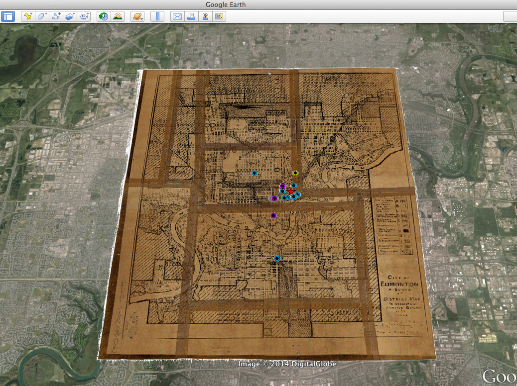
Archival map of City of Edmonton, 1933, georeferenced and overlaid into Google Earth imagery
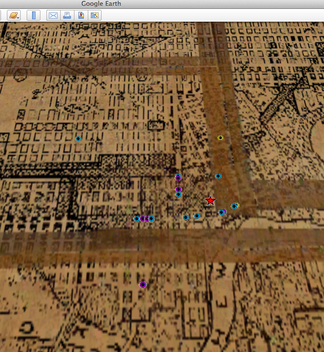
Detail: Archival map of City of Edmonton, 1933. Downtown area showing CLDL (red), booksellers (purple), newsstands (blue), and meeting places (yellow)
What I mean to say is, it worked. IT WORKED! For the first time in five years, I came to DHSI with an idea and some data, learned the right skills well enough to put the idea into action, and to complete something immediately usable and still extensible.
This affords an excellent opportunity for reflecting on this process, as well as the work of many other DH projects. What makes it work? I have a few ideas:
1. Expectations. Previous courses, experiments, and failures have begun to give me a sense of the kind of data that is usable and the kind of outcomes that are possible in a short time. A small set of data, with a small outcome – a test, a proof, a starting place – seems to be most easily handled in the five short days of DHSI, and is a good practice for beginning larger projects.
2. Previous skills. Last year, I took Harvey Quamen’s excellent Databases course, which gave me a working knowledge of tables, queries, and overall data organization, which helped to make sense of the way GIS tools operated. Data-mining and visualization would be very useful for the GIS course as well.
3. Preparation. I came with a map in a high-resolution TIFF format, as well as a few tables of data pulled from the archive sources I listed above. I did the groundwork ahead of time; there is no time in a DHSI intensive to be fiddling with address look-ups or author attributions. Equally, good DH work is built on a deep foundation of research scholarship, pulling together information from many traditional methods and sources, then generating new questions and possibilities that plunge us back into the material. Good sources, and close knowledge of the material permit more complex and interesting questions.
4. Projections. Looking ahead to what you want to do next, or what more you want to add helps to stymie the frustration that can come with DH work, while also connecting your project to work in other areas, and adding momentum to those working on new tools and new approaches. “What do you want to do?” is always in tension with “What can you do now?” – but “now” is always a moving target.
5. Collaboration. I am wholly indebted to the work of other scholars, researchers (published and not), librarians, archivists, staff, students, and community members who have helped me to gather even the small set of data used here, and who have been asking the great questions and offering the great readings that I want to explore. The work I have detailed here is one throughline of the work always being done by many, many people. You do not work alone, you should not work alone, and if you are not acknowledging those who work with you, your scholarship is unsustainable and unethical.
While I continue to work through this project, and to hook it into other areas of research and collaboration, these are the points that I try to apply both to my research practices and politics. How will we continue to work with each other, and what makes it work best?